




-National Weather Service-
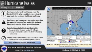
A Flood Watch is in effect from late Friday night through Sunday morning.
Hurricane Isaias is expected to bring rounds of heavy rainfall to the area late Friday through early Sunday.
Widespread totals of 1 to 3 inches are expected with localized amounts of 5 inches.
Excessive runoff may result in flooding of rivers, creeks, streams, and other low-lying and flood-prone locations.
Hurricane Isaias is expected to bring rounds of heavy rainfall to the area late Friday through early Sunday.
Widespread totals of 1 to 3 inches are expected with localized amounts of 5 inches.
With high rainfall rates and the potential for repeated rounds of heavy rain in bands, flash flooding is expected.
The locations most at risk are poor drainage and urban areas, as well as creeks and streams prone to flash flooding.
You should monitor later forecasts and be alert for possible Flood Warnings.
Those living in areas prone to flooding should be prepared to take action should flooding develop.
There is also a high wind watch in effect
East winds 15 to 25 mph with gusts up to 50 mph possible for potions of north central, northeast, northwest, and west central Georgia from Saturday morning through Sunday morning.
Damaging winds could blow down trees and power lines.
Widespread power outages are possible. Travel could be difficult, especially for high profile vehicles.

Comments